Prince Edward Island Route 6
 Route 6 | ||||
|---|---|---|---|---|
| Route information | ||||
| Maintained by Prince Edward Island Transportation and Public Works | ||||
| Length | 68.7 km[1] (42.7 mi) | |||
| Major junctions | ||||
| West end |   Route 2 / Route 20 in Kensington Route 2 / Route 20 in Kensington | |||
 Route 8 / Route 20 at New London Route 8 / Route 20 at New London
 Route 25 at Covehead and Stanhope Route 25 at Covehead and Stanhope | ||||
| East end | Route 2 at Bedford Corner | |||
| Location | ||||
| Country | Canada | |||
| Province | Prince Edward Island | |||
| Counties | Prince, Queens | |||
| Highway system | ||||
|
| ||||
| ||||
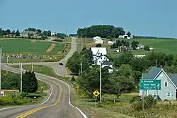
Prince Edward Island Route 6 is a secondary highway in central Prince Edward Island.
Route 6 begins in Kensington at the junction of Routes 2 and 20, bearing east. It passes the community of New London before turning at a roundabout in Stanley Bridge. It is the main road through Cavendish, meeting Route 13 in the town, then turning south towards North Rustico. It meets Route 7 at Oyster Bed Bridge, turning east once again. Route 6 is co-signed with Route 15 for 3.5 kilometres (2.2 mi) south of Brackley Beach, then Route 6 proceeds east through Covehead and Stanhope, cosigned with Route 25 for 1.9 kilometres (1.2 mi). It turns south once again near Grand Tracadie before terminating at Route 2 at Bedford Corner, near Dunstaffnage.[2]
Major intersections
| County | Location | km[1] | mi | Destinations | Notes |
|---|---|---|---|---|---|
| Prince | Kensington | 0.0 | 0.0 | Route 2 west (Victoria Street) – Summerside Route 2 east / Route 20 north (Broadway Street) – Charlottetown, Malpeque | Western terminus |
| 0.07 | 0.043 |  Route 101 north (Woodleigh Drive) – Park Corner Route 101 north (Woodleigh Drive) – Park Corner | |||
| Margate | 4.5 | 2.8 |  Route 104 north Route 104 north | ||
| Prince—Queens county line | | 5.0 | 3.1 |  Route 233 south (County Line Road) Route 233 south (County Line Road) | |
| Queens | Clinton | 7.9 | 4.9 |  Route 107 south (Kerrytown Road) Route 107 south (Kerrytown Road) | |
| New London | 11.3 | 7.0 | Route 20 north / Route 8 south (Grahams Road) – French River, Summerfield | ||
| | 12.8 | 8.0 |  Route 238 (Fountain Road / Campbellton Road) Route 238 (Fountain Road / Campbellton Road) | ||
| Stanley Bridge | 15.2 | 9.4 | Route 238 north (Campbellton Road) | ||
| 15.9 | 9.9 |  Route 254 south (Rattenbury Road) – North Granville, Springfield Route 254 south (Rattenbury Road) – North Granville, Springfield Route 224 east (St. Marys Road) – Hope River, New Glasgow Route 224 east (St. Marys Road) – Hope River, New Glasgow | Roundabout | ||
| Cavendish | 20.3 | 12.6 | Grahams Lane | ||
| 22.9 | 14.2 |  Route 13 (to West Gulf Shore Parkway) – Prince Edward Island National Park, New Glasgow, Hunter River Route 13 (to West Gulf Shore Parkway) – Prince Edward Island National Park, New Glasgow, Hunter River | |||
| North Rustico | 30.0 | 18.6 | Harbourview Drive (to West Gulf Shore Parkway) − Prince Edward Island National Park | ||
| 26.8 | 16.7 |  Route 269 west (Line Road) Route 269 west (Line Road) | |||
| Rusticoville | 29.2 | 18.1 |  Route 258 west – New Glasgow Route 258 west – New Glasgow | ||
| | 35.0 | 21.7 |  Route 243 north (Buntain Road) Route 243 north (Buntain Road) | ||
| South Rustico | 36.0 | 22.4 | Route 243 (Church Road) | ||
| 36.3 | 22.6 |  Route 242 east (Grand Pere Point Road) Route 242 east (Grand Pere Point Road) | |||
| | 39.3 | 24.4 | Route 242 west (Grand Pere Point Road) | ||
| Oyster Bed Bridge | 41.6 | 25.8 |   Route 7 south (Rustico Road) / Route 251 west (Crooked Creek Road) – Charlottetown, Wheatley River Route 7 south (Rustico Road) / Route 251 west (Crooked Creek Road) – Charlottetown, Wheatley River | Roundabout | |
| 42.1 | 26.2 |  Route 223 south (Winsloe Road) Route 223 south (Winsloe Road) | |||
| Brackley Beach | 45.5 | 28.3 |  Route 15 north – Prince Edward Island National Park Route 15 north – Prince Edward Island National Park | West end of Route 15 concurrency | |
| Brackley Point | 48.0 | 29.8 | Route 15 south – Charlottetown | East end of Route 15 concurrency | |
| | 49.9 | 31.0 |  Route 221 south (Union Road) Route 221 south (Union Road) | ||
| | 50.8 | 31.6 |  Route 252 east (MacMillan Point Road) Route 252 east (MacMillan Point Road) | ||
| West Covehead | 52.0 | 32.3 | Route 252 west (MacMillan Point Road) | ||
| 52.5 | 32.6 |  Route 25A south (West Covehead Road) Route 25A south (West Covehead Road) | |||
| Covehead | 53.6 | 33.3 | Route 25 south – Charlottetown | West end of Route 25 concurrency | |
| Stanhope | 55.5 | 34.5 | Route 25 north – Covehead Harbour, Prince Edward Island National Park | East end of Route 25 concurrency | |
| Dalvay | 58.9 | 36.6 | Gulf Shore Parkway − Prince Edward Island National Park | ||
| Grand Tracadie | 60.4 | 37.5 |  Route 220 south (Pleasant Grove Road) Route 220 south (Pleasant Grove Road) | ||
| | 63.7 | 39.6 |  Route 219 east (Donaldson Road) Route 219 east (Donaldson Road) | ||
| Millcove | 65.8 | 40.9 |  Route 229 west (Millcove Road / Dougan Road) Route 229 west (Millcove Road / Dougan Road) | ||
| Bedford Corner | 68.7 | 42.7 | Route 2 – Souris, Charlottetown | ||
1.000 mi = 1.609 km; 1.000 km = 0.621 mi
| |||||
References
- ^ a b "PEI Route 6" (Map). Google Maps. Retrieved September 16, 2019.
- ^ Prince Edward Island Provincial Road Atlas (PDF) (Map) (2014 ed.). Government of Prince Edward Island. pp. 18, 22–23, 26, 29. Retrieved September 16, 2019.